Q. Explain the origin of the Himalayas with the support of Plate Tectonics Theory. [39 BPSC/1993]
The Himalayas mountain range formed as a result of the continent-continent collision between the Indian Plate and Eurasian Plate which began 50 million years ago and continues today. The theory of plate tectonics states that the Earth’s solid outer crust, the lithosphere, is separated into plates that move over the asthenosphere, the molten upper portion of the mantle. Oceanic and continental plates come together, spread apart, and interact at boundaries all over the planet.
The origin of the Himalayas with the support of Plate Tectonics Theory:
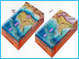

- 225 million years ago (Ma) India was a large island situated off the Australian coast and separated from Asia by the Tethys Ocean.
- The supercontinent Pangea began to break up 200 Ma and India started a northward drift towards Asia.
- 80 Ma India was 6,400 km south of the Asian continent but moving towards it at a rate of between 9 and 16 cm per year. At this time Tethys Ocean floor would have been subducting northwards beneath Asia and the plate margin would have been a Convergent oceanic-continental one just like the Andes today.
- However not all of the Tethys Ocean floor was completely subducted, most of the thick sediments on the Indian margin of the ocean were scraped off and accreted onto the Eurasian continent in what is known as an accretionary wedge.
- These scraped-off sediments are now form the Himalayan mountain range.
- From about 50-40 Ma the rate of northward drift of the Indian continental plate slowed to around 4-6 cm per year. This slowdown is interpreted to mark the beginning of the collision between the Eurasian and Indian continental plates, the closing of the former Tethys Ocean, and the initiation of Himalayan uplift.
- The Eurasian plate was partly crumpled and buckled up above the Indian plate but due to their low density/high buoyancy neither continental plate could be subducted.
- This caused the continental crust to thicken due to folding and faulting by compressional forces pushing up the Himalaya and the Tibetan Plateau.
- The continental crust here is twice the average thickness at around 75 km.
- The thickening of the continental crust marked the end of volcanic activity in the region as any magma moving upwards would solidify before it could reach the surface.
The Himalayas are still rising by more than 1 cm per year as India continues to move northwards into Asia, which explains the occurrence of shallow focus earthquakes in the region. However the forces of weathering and erosion are lowering the Himalayas at about the same rate.